
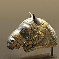
History and culture
Kerman province is considered a paradise for paleontologists because of an abundance of vertebrate fossils from different geological eras. Fossils include Placodermi, jawed and jawless armored fish dating back to the Devonian period (395 to 365 million years ago), dinosaurs (195 to 66 million years ago) and mammals from the Tertiary period (ranging from two to seventy million years ago).
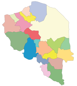
The history of human settlements in the territory of Kerman dates back to the 4th millennium BC. This area is considered as one of the ancient regions of Iran and valuable historical vestiges have been discovered here. Jiroft is an example, where a previously unknown settlement dating back to around 2500 BC has been established by archeologists. Kerman has an abundance of historical sites and landmarks, 283 in total, according to Iran’s Cultural Heritage Organization. Ancient abandoned citadels such as
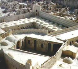
Arg-é Bam and Rayen castle have been preserved in the desert for 2,000 years.
Historical documents refer to Kerman as “Karmania” (in Ancient Greek Καρμανία), “Kermania”, “Germania”, “Carmonia”, and “Žermanya”, which means bravery and combat. Geographers have recorded Kerman’s ancient name as “Go’asheer” (Bardesheer).
Geography
The altitudes and heights of the province are the continuation of the central mountain ranges of Iran. They extend from the volcanic folds beginning in Azarbaijan and, by branching out in the central plateau of Iran, terminate in Baluchestan. These mountain ranges have brought about vast plains in the province.
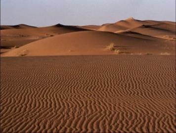
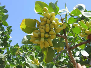
Most of the province is largely steppe or sandy desert, although there are some oases where dates, oranges (said to be the best in Iran), and pistachios are cultivated. The province is dependent on Qanats (underground water channels) for its irrigation. In the central parts, Mount Hezar is the highest peak, 4465 meters above sea level.
Climate
The climate in the province varies across regions. The north, northwest, and central areas experience a dry and moderate climate, whereas in the south and southeast, the weather is warm and relatively humid. The city of Kerman and the surrounding regions have a semi-moderate and dry climate, with a maximum and minimum temperature of 39.6°C, and -7°C respectively.
The average temperature during the months of March-June has been recorded as 20°-25°C. These months are the most suitable for traveling and tourism.
Demography
In addition to Muslims, Kerman also has a small but culturally significant Zoroastrian minority.
In 2011 the population of the province was 2,938,988.
In 1996, 52.9% of Kerman’s population lived in urban areas, and 46% in rural vicinities, the remaining 1.1% accounted as non-residents. The city of Kerman (2011 population: 621,374) embraces about 80% of the urban population, being the most developed and largest city of the province.
Economy
As of 1920, the province was known for the quality of its caraway. Today, Kerman is where a large portion of Iran’s auto industry is based. Sirjan, a specially designated economic zone, is considered a passage-way for transfer of imported commercial goods from the south (through the Persian Gulf). Arg e Jadid, is another specially designated economic zone of Iran, located in Kerman province.
Education
Colleges and universities
Kerman province contains the following universities:
1. Kerman University of Medical Sciences
2. Bahonar University of Kerman
3. Rafsanjan University of Medical Sciences
Kerman City
The capital of Kerman province is also called Kerman. At the 2011 census, its population was 821,374, in 221,389 households, making it the 10th most populous city of Iran.It is the largest and most developed city in the Kerman Province and the most important city in South-East Iran. It is one of the largest cities of Iran in terms of area. Kerman is famous for its long history and strong cultural heritage. The city is home to many historic mosques
and Zoroastrian fire temples. Kerman is also on the list of the recent world’s 1000 cleanest cities. Kerman is also a former capital of Iran, a position that it held during several periods. It is located on a large, flat plain, 1,036 km (643 mi) south of Tehran, the capital of Iran.
History
Kerman was founded as a defensive outpost, with the name Behdesīr, by Ardeshir I, founder of, in the 3rd century AD. After the Battle of Nahāvand in 642, the city came under Muslim rule. At first the city’s isolation allowed Kharijites and Zoroastrians to thrive there, but the Kharijites were wiped out in 698, and the Sassanid Empire the population was mostly Muslim by 725. Already in the eighth century the city was famous for its manufacture of cashmere wool shawls and other textiles. The Abbasid Caliphate’s authority over the region was weak, and power passed in the tenth century to the Buyid dynasty, which maintained control even when the region and city fell to Mahmud of Ghazna in the late tenth century. The name Kerman was adopted at some point in the tenth century.

In 1793 Lotf Ali Khan defeated the Qajars and in 1794 captured Kerman. But soon, he was besieged in Kerman for six months by Agha Mohammad Khan. When the city fell to Agha Mohammad Khan, angered by the popular support that Lotf Ali Khan had received, all the male inhabitants were killed or blinded, and a pile was made out of 20,000 detached eyeballs and poured in front of the victorious Agha Muhammad Khan. The women and children were sold into slavery, and the city was destroyed over ninety days.
The present city of Kerman was rebuilt in the 19th century to the northwest of the old city, but the city did not recover to its former size until the 20th century.
Geography
Kerman is located on a high margin of Kavir-e Lut (Lut Desert) in the central south of Iran. The city is surrounded by mountains. Kerman is also located along the Saheb Al Zaman mountain .The city is 1,755 m (5,758 ft) above sea level that makes it the third capital city(of a province) in Iran with the highest Elevation. Winter has very cold nights in Kerman. Mountains in the South and South East of Kerman have snow all year round.
Climate
The city’s many districts are surrounded by mountains which bring variety to Kerman’s year round weather pattern, thus the northern part of the city is located in an arid desert area, while the highland of the southern part of the city enjoys a more moderate climate.
Kerman city has a moderate climate and the average annual rainfall is 135 mm. Because it is located close to the Kavir-e lut, Kerman has hot summers and in the spring it often has violent sand storms. Otherwise, its climate is relatively cool.
Geological characteristics
For the Iranian paleontologists, Kerman has always been considered a fossil paradise. Finding new dinosaur footprints in 2005 has now revealed new hopes for paleontologists to better understand the history of this area
Economy
The economy of Kerman is mostly based on farming, notably nut farming and also mining. Sarcheshmeh Copper mine is the second biggest copper mine in the world after the one located in Chile. Pistachio is an important source of economy in Kerman, with Kerman Province being the biggest producer of pistachio in Iran and all over the world.
Carpet weaving is one of the main industries of the city, and the carpets produced there are renowned internationally. Carpet
weaving is a very old tradition in Kerman. The oldest carpet
discovered in Kerman, dates from about 500 years ago, which proves the precedence of weaving in this city. Among the most famous Kerman carpet producers of the 19th & 20th centuries include Costigian, Ghastili and Dilmaghani, the latter still in operation & considered an important connection of 19th and 20th century production of carpets in Kerman. Cotton textiles and goats-wool shawls are also manufactured.
A number of modern establishments such as textile mills and brickworks also have been constructed. The province’s mineral wealth includes copper and coal.
Culture
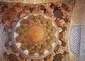
Kerman is among several cites in Iran with a strong cultural heritage, which is expressed in the local accent, poetry, local music, handicrafts and customs that Kerman has introduced to the world of culture.The only anthropology Iran museum of Zoroastrians in the world, which showcases the ancient history of Zoroastrians, is in Kerman’s Fire Temple. The museum was officially inaugurated during Jashn-e Tirgan in 2005. Jashn-e Tirgan or Tiregan is an ancient Iranian rain festival observed on July 1. The festivity refers to archangel Tir (literally meaning arrow) or Tishtar (lightning) which appears in the sky to generate thunder and lightning to provide much needed rain.
Sadeh ceremony is celebrated every year in Kerman.
Also The archeological ancient area of Jiroft and Tappe Yahya Baft are located south of Kerman.Rayen Castle is also located on Rayen town,south east of Kerman.


